“Harbours and safety” menu: harbours, anchorages, slipways, restricted areas, rescue
User guide · updated 19.10.2026
Where to stop, where to launch, where you're not allowed to go, and who to call if something goes wrong.
What this menu is for
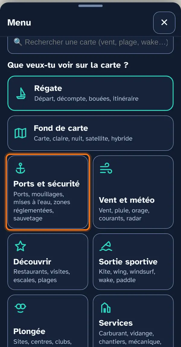
The harbours and safety menu: twelve layers in a simple list, with no submenu.
- Stopping: marinas, anchorages, mooring buoys and berths, pontoons and jetties, and for Geneva the berths and mooring buoys.
- Launching: slipways (verified) and launching ramps (OpenStreetMap).
- Scheduled boats: landing stages and next departures of CGN boats.
- What is prohibited or marked: restricted areas and flashing lights.
- Emergency services: rescue (SISL and emergency services), rescue sections, lake police and gendarmerie.
Fuel, pump-out, toilets and cranes are in Services; waves, shelter and depths in Lake info; anchor and shallow-water alarms in “Where to?”.
How to use it
Open the menu
Tap Menu, bottom right, then the menu's tile. At the top: 📖 User guide for this menu (this page) and ↺ Reset maps, which switches everything off at once.
No submenu here: the twelve layers are in a list, each with its note. The two Canton of Geneva layers (berths and mooring buoys, marked “Geneva”) are at the end of the list.
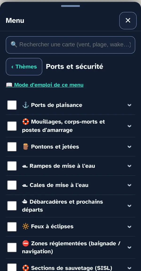
Turn on a map layer
Tick a map layer's box to lay it over the base map; untick it to remove it. The arrow at the right of the row opens its info note: what the layer shows, its colour key, its source and what it doesn't tell you. An OFFLINE label marks a layer built into the app, which works without signal.
Two pairs look alike: “Slipways” (checked site by site, offline) and “Launching ramps” (OpenStreetMap). Use the first to decide, the second so you miss nothing. The same goes in Geneva for “Anchorages, mooring buoys and berths” (OpenStreetMap) and “Mooring buoys (Geneva)” (SITG, Geneva only).
Why checkboxes? So that only what's useful right now goes on the map: ten layers switched on together become unreadable.
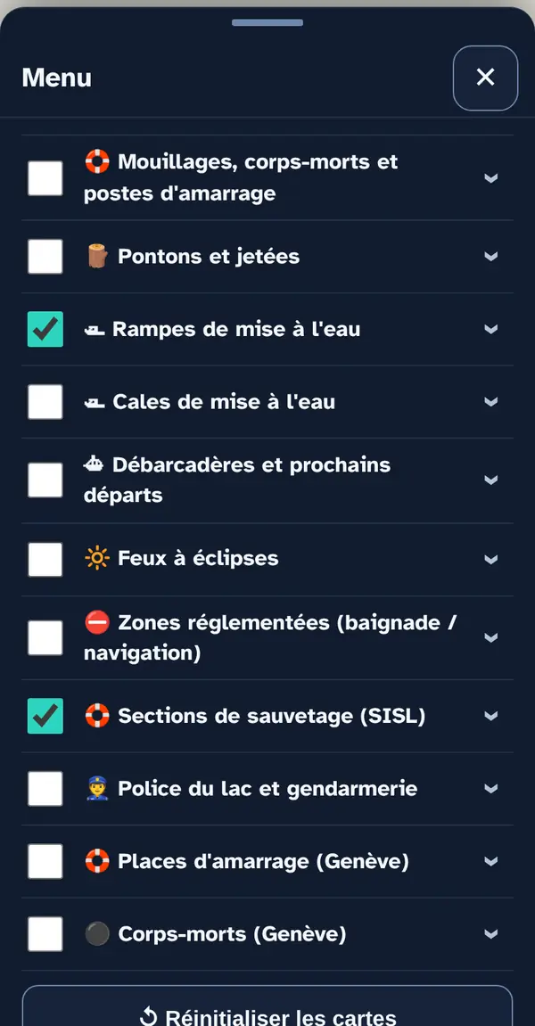
Reading the map
Each layer has its own icon and colour: here the slipways and rescue sections on La Côte. Zoom in to separate nearby points.
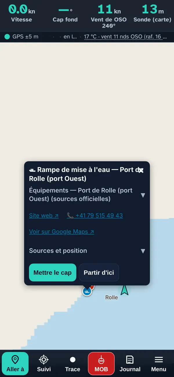
Tap a point: the pop-up
- The name, preceded by the layer's icon.
- Facilities — harbour name (expandable): when the place bears a harbour's name, that harbour's facilities confirmed by an official source (slipway, crane, pump-out, fuel) and the harbour master's office phone number.
- The practical note when known: access from the beach or the nearby harbour, season, booking.
- A row of links: the website ↗, the phone number (one tap calls) and “View on Google Maps ↗”.
- Sources and position (expandable): where the place comes from and how its position was obtained — official address, OpenStreetMap or read off the map.
- Set course makes it your destination in “Where to?”; Start from here, your starting point.
Tapping the map away from a place opens the Selected point pop-up: its coordinates, then what the active layers know about that point — the bottom, water temperature, current, likely species — and the Go here and Start from here buttons.
How the data is cross-checked
These layers bring together three kinds of sources, always kept separate:
- Official maps: harbours, restricted areas and flashing lights (CIPEL), Geneva berths and mooring buoys (SITG) — read live, so with a connection.
- The app's verified files: slipways, rescue sections, lake police and gendarmerie — each place checked against an official source.
- OpenStreetMap: pontoons and jetties, launching ramps, anchorages — more complete, but unverified, and kept in separate files (ODbL licence).
The landing stages come from the Swiss public timetable: the next departures load live.
The map layers in this menu
Forecast maps (wind, rain, currents, waves, water temperature…) bring up a time slider at the bottom of the screen: drag the slider and they are recalculated for the chosen time.
⚓ Marinas
The marinas around the lake, on both shores. When the harbour is recognised, the pop-up adds the facilities confirmed by an official source (municipality, harbour master's office, canton) and the harbour master's phone number. When a panoramic webcam is 1 km away or less, the pop-up links to it (list from the Webcams layer, Weather section).
Tip. Tap a harbour: its confirmed facilities (slipway, crane, pump, fuel), the harbour master's office phone number when published, and “Set course” to go there.
Good to know. Facilities checked in October 2026: only those confirmed by an official page are shown. A facility missing from the pop-up may still exist — ask the harbour master.
Source: CIPEL — International Commission for the Protection of the Waters of Lake Geneva
🛟 Anchorages, mooring buoys and berths
Anchorages, mooring buoys and berths as mapped by OpenStreetMap contributors. Built-in file: works offline.
110 points from OpenStreetMap (37 Geneva, 17 La Côte, 16 Lausanne and Lavaux, 2 Riviera and Valais Chablais, 38 French shore).
Good to know. Crowd-sourced and patchy: a missing mooring buoy here proves nothing, and one that is shown tells you neither whose it is nor what load it can take.
Source: OpenStreetMap and its contributors, ODbL licence · data as of 24.07.2026, frozen on 17.10.2026
🪵 Pontoons and jetties
Pontoons and jetties, extracted once and for all into a built-in file: this layer works offline.
1504 points from OpenStreetMap (571 Geneva, 401 La Côte, 186 Lausanne and Lavaux, 90 Riviera and Valais Chablais, 256 French shore).
Good to know. It's a snapshot: it will only change at the next extraction.
Source: OpenStreetMap and its contributors, ODbL licence · extract of 21.09.2026
🛥 Slipways
Slipways around the lake: those at harbours where an official source confirms the slipway, and those mapped in OpenStreetMap (beaches, quays, harbours). The pop-up says where each one comes from and whether access is restricted.
65 places on the map (18 Geneva, 14 La Côte, 8 Lausanne and Lavaux, 11 Riviera and Valais Chablais, 14 French shore), 48 with a website, 47 with a phone number, 5 with a practical note (access, season…).
Good to know. A slipway that comes only from OpenStreetMap is marked “partly confirmed”: it exists on the collaborative map, but no official page mentions it. It may charge a fee, be reserved for residents or be closed in winter — call the harbour master before coming with a trailer.
Source: Official harbour pages (October 2026); OpenStreetMap, leisure=slipway (© OpenStreetMap contributors, ODbL) · October 2026
🛥 Launching ramps
Launching ramps. Built-in file: works offline.
82 points from OpenStreetMap (17 Geneva, 16 La Côte, 17 Lausanne and Lavaux, 12 Riviera and Valais Chablais, 20 French shore).
Good to know. Neither the slope, the draught nor the right of use is guaranteed — some ramps are private or charge a fee.
Source: OpenStreetMap and its contributors, ODbL licence · data as of 16.10.2026, frozen on 17.10.2026
⛴ Landing stages and next departures
The CGN landing stages. Tap a pier to see the actual next departures.
Tip. Tap a landing stage for the next departures; keep 50 m clear of passenger ships and their route.
Good to know. A passenger ship follows a fixed route and is slow to manoeuvre: it's up to us to keep clear.
Source: Swiss public timetable (transport.opendata.ch)
🔆 Flashing lights
The lake's official flashing lights, with their position.
Tip. The pop-up gives the light's area and a Google Maps link to its position.
Good to know. The nautical chart and the navigation regulations have the final say: this layer locates the lights, it doesn't describe their sectors.
Source: CIPEL — International Commission for the Protection of the Waters of Lake Geneva
⛔ Restricted areas (swimming / navigation)
Areas where swimming or navigation is restricted or prohibited. Check before anchoring, diving or launching. Includes the Geneva harbour (rade), inside the Pâquis and Jet d'eau jetties: prohibited to craft without an engine (approximate outline).
Tip. Turn on before anchoring, diving or launching.
Good to know. The exact wording of the restriction prevails. An area may be seasonal, and cantonal or prefectoral orders change without this layer being updated.
Source: CIPEL — International Commission for the Protection of the Waters of Lake Geneva (survey 2025); Geneva harbour: Geneva navigation act (LNav), art. 10
🛟 Rescue sections (SISL)
The sections of the International Lake Geneva Rescue Society (SISL), with their premises and phone number where published.
30 places on the map (4 Geneva, 5 La Côte, 6 Lausanne and Lavaux, 9 Riviera and Valais Chablais, 6 French shore), 30 with a website, 20 with a phone number.
Tip. In an emergency, call 117 (CH) or 112 first: a section is not a manned station.
Good to know. A section is not a permanently manned station: in an emergency, call 117 in Switzerland, 18 or 112 in France.
Source: Official source for each place (its website, the municipality, the tourist office, the canton), rechecked in October 2026 and named in the pop-up; position taken from the official address (geo.admin.ch, IGN); distance to the water calculated on swissBATHY3D · October 2026
👮 Lake police and gendarmerie
The lake police and the waterside gendarmerie stations. Each pop-up says whether it's the lake police or an ordinary station.
7 places on the map (1 Geneva, 1 La Côte, 1 Lausanne and Lavaux, 2 Riviera and Valais Chablais, 2 French shore), 7 with a website, 7 with a phone number.
Good to know. The French water brigade in Évian has no published address, so it isn't on the map. Emergency: 117 in Switzerland, 17 or 112 in France.
Source: Official source for each place (its website, the municipality, the tourist office, the canton), rechecked in October 2026 and named in the pop-up; position taken from the official address (geo.admin.ch, IGN); distance to the water calculated on swissBATHY3D · October 2026
🛟 Berths (Geneva)
Berths recorded by the canton of Geneva.
Good to know. Geneva only: nothing for Vaud, Valais or Haute-Savoie.
Source: SITG — Système d'information du territoire genevois
⚫ Mooring buoys (Geneva)
Mooring buoys recorded by the canton of Geneva.
Good to know. Geneva only. A mapped mooring buoy tells you neither who owns it nor what load it can take.
Source: SITG — Système d'information du territoire genevois
What this menu tells you, and what it doesn't
What it tells you. Where the harbours, anchorages, launch sites, rescue services and prohibited areas are.
What it doesn't tell you. None of these layers is a nautical chart: a missing object proves nothing, and one that is shown tells you neither who owns it nor what load it can take.
Navleman is a navigation aid, not an official nautical document: the official chart, the storm warning lights and the authorities' instructions always take precedence.